Thursday, October 26, 2017

Railroads of Greece 6: Abandoned Steam Trains, Myloi

Myloi is the final resting place for old steam locomotives. The town is on the west side of the Bay of Naufplio (Nauplion), which is at the north end of the Argolic Gulf in southern Greece. The narrow-gauge Peloponnese railroad passes through town. The main line to Athens comes in from the north via the town of Argos. Heading south, the rail line runs along the coast and then turns west and ascends the mountains to eventually reach Tripoli, the main town in the central Peloponnese.
Not much is happening at the rail yard now. Not long ago, many of the track beds were overhauled and new rails laid, as shown by the clean crushed rock in the second photograph. But after spending significant funds on upgrades, the Greek national railway system abruptly stopped rail service on the narrow gauge system in most of the Peloponnese. What an amazing bike and hike trail this would make.
The real reason to stop in Myloi is to look at the old steam locomotives, many of which have been abandoned for decades. I have no idea why they were parked here rather than sold for the scrap iron.
Asbestos cement is dripping off the boilers.
More old locomotives are parked among the huge eucalyptus trees. I do not know the types or manufacture, but there are web pages that have inventoried lost locomotives around the world.
This is one of the water tanks that once supplied water to the locomotive tenders. The need for water to generate steam was a major logistical problem in the steam locomotive era. Today, a diesel locomotive only needs diesel fuel and it can run for days.
A family was living in the old train workshop, possibly immigrants. They had bicycles and laundry.
One diesel-electric unit was abandoned on a siding.
What do you do when you are finished exploring trains? Well, you go to the taverna and eat fish and squid, of course. These small seaside restaurants do an amazing job - and the ingredients are locally sourced. None of this processed crap full of artificial ingredients and salt that comes in on a Sysco truck.

Please click the link to see black and white photographs of the Myloi rail yard. 

Most images are digital from my Fuji X-E1 digital camera.

Monday, October 16, 2017

Travels on the Mother Road, Route 66: Part 10a, Return to Kasha-Katuwe Tent Rocks National Monument, New Mexico

Dear Readers, I drove another piece of Route 66 in 2017, from Santa Fe, New Mexico, to Tulsa, Oklahoma. We will continue our tour of the Mother Road with a short return hike in the amazing Kasha-Katuwe Tent Rocks National Monument. Archaeologists have documented evidence of 4000 years of human habitation in the region. This implies a dependable water supply throughout the year. The Peublo de Cochiti people still inhabit the surrounding area. My trip was in July, the "monsoon" season in New Mexico, and the skies were amazing with towering thunderheads. Also, this time, I used black and white film instead of digital.
The Slot Canyon Trail is an easy way to get the feel of the desert, rock formations, and views. From a parking at about 5,200 ft altitude, you gradually ascend across dusty desert and enter a narrow slot canyon. You wind your way through the narrow canyon with vertical walls, and then ascend to the plateau at about 6,300 ft. The last part is steep but well-marked. The trail ends at an overlook of the Monument’s teepee (or tent) shaped rock formations.
As I wrote before, these teepees remind me of the cones of tuffa in Cappadocia, in central Anatolia (Turkey). Read more about the geology at the New Mexico Bureau of Geology & Mineral Resources.
The bent-over and weathered trees are especially interesting.
Late afternoon, and the lightning crackles in the distance, and the thunders rumbles. The signs warn you about flash floods. But the tourists were still coming in and heading to the slot canyon.

I took these photographs with my Yashica Electro 35CC camera (with 35mm f/1.8 Color-Yashinon lens) using Kodak BW400CN film. I scanned the negatives with a Plustek 7600i scanner. Note, in the 1970s, the word "color" was applied to all sorts of optics to demonstrate that they were so superior, you could use them for color film. Brilliant. Today, the marketers would use the word "digital" instead. Or maybe they would use "nano."

Saturday, October 7, 2017

Small Towns in Mississippi: Return to Edwards (B&W film)

Kansas City Southern railroad and Front Street, Edwards, Mississippi
Edwards, Mississippi, is a small town just south of Interstate 20, near a bend of the Big Black River. Before World War II, the Big Black was a Federal navigation project and was dredged and kept clear of snags, but now it is no longer maintained for commercial traffic. Like many small Mississippi towns, Edwards was prosperous up through the 1970s, but has slipped into a multi-decade decline and population loss. As usual, I do not understand the causes, considering the town is on the Kansas City Southern rail line between Vicksburg and Jackson and has easy road access to I-20. It is a mystery.
Walker Evans (American, 1903 - 1975) Railroad Station, Edwards, Mississippi, 1936, Gelatin silver print 19.3 x 24.2 cm (7 5/8 x 9 1/2 in.). The J. Paul Getty Museum, Los Angeles
This is supposed to be a picture of Edwards taken in 1936 by Walker Edwards. Was it taken from the same bridge as my photograph no. 1 above? Was there once another bridge or crossover from which Evans took this frame? Where is the church on the left? I think the 1936 photograph may be mis-labeled and show another town. But it is not Bolton nor Bovina.
Front Street parallels the KCS tracks. The city hall is there, with the police department a short distance away.
103 Magnolia St., Edwards, MS
205 Magnolia St., Edwards, MS
Magnolia Street has some gracious old houses, demonstrating former wealth in the town.
This is the former Dodge automobile dealer, at the corner where old U.S. 80 makes a sharp right-angle turn. An old-timer in town told me that Edwards was prosperous enough in the 1970s to have two car dealerships. (Update April 21, 2018: the old car shop is being demolished)
The high school gymnasium was designed by architect James Manly Spain in the Art Moderne style. It was completed just before we entered World War II in 1941 by the National Youth Administration (from the Mississippi Department of Archives and History). I have photographed this building before, and there has been no change in status.
The water tower is a prominent feature at the corner of U.S. 80 and Main Street. I was surprised it was over a century old. The big rivets are an example of early 20th century steel and iron construction. This was solid construction, intended to last the ages.
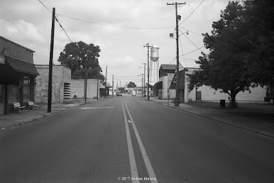
Main Street, which runs north-south, was once, well, the main street, with stores and small companies.
Both the east and west sides of South Main have stores with collapsed roofs. (Update April 21, 2018: this southernmost building has been demolished)
On Main Street north of the tracks, the former Woodmen of America building was in poor condition in 2008. A former coworker from the Waterways Experiment Station had bought the historic building to preserve it, but the task may have been too much for her. It is now gone. Other historic buildings on Main Street were demolished in the mid-2000s, with the bricks salvaged for use in McMansion construction (recall, this was in the last gasp of the construction orgy before the 2007-2008 housing collapse).  Much of Utica's former commercial core suffered the same fate.
Drive around the streets and the scene is pretty depressing. Joe's Lounge on Utica Street is a short distance from a collapsed store. (Update April 21, 2018: the collapsed store is gone and the lot is empty.)
On Williams Drive, a store of modern construction, also closed.
Just off I-20, the fellow who restores old cars still has interesting Detroit iron in his yard. I am not sure if all these very cars are still there because the lot looks a bit more empty now. I have not seen any Edsels recently, but there may be some in there under the kudzu.

I took the 2017 photographs with my Yashica Electro 35CC compact rangefinder camera on Ilford Delta 100 film. There was rain and drizzle, and the contrast worked out perfectly with this film and development. I bought this little Yashica as a convenient walkabout camera for an upcoming trip to Nepal. The 35mm Æ’/1.8 Color Yashinon-DX lens, a Sonnar type, is very high quality. Praus Productions in Rochester, NY developed the film.

The 2008 frame of the old Chevrolets is from Kodak Panatomic-X film, taken with a Fujifilm GW690II medium format camera.

Sunday, October 1, 2017

The Arkansas Delta 2: McGehee (B&W film)

North First Street or US. 287, McGehee, Arkansas.
Dear Readers, many of my previous posts have been about the Mississippi Delta. Cross the Mississippi River to the west side, and there is a similar flat alluvial plain in Arkansas, which comprises it's "Delta." Note, I am not referring to the geomorphic delta of the Mississippi River. That is the immense mass of riverine sediment that protrudes south into the Gulf of Mexico in southern Louisiana. For reasons I do not know, the flat alluvial plain that was so fertile for agriculture in northwest Mississippi and southeast Arkansas was historically also called the "Delta."
McGehee, a city in Desha County, is one of these agricultural and railroad junction towns in the Arkansas Delta. McGehee developed in the 1870s, when the railroad was cut through this area of undeveloped hardwood bottomlands and marshes. A sawmill was one of the first industries.
The rail lines, still active and an important commerce routing, are now operated by Union Pacific Railroad.
The Missouri-Pacific Depot was built in 1910, in a Mediterranean/Italianate style, combining Spanish tiles on the roof and exposed beams with a Craftsman appearance. The depot has been restored and is on the National Register of Historic Places. Hord Architects of Memphis, TN, and Miller-Newell Engineers restored the North Building of the McGehee Train Depot, with funding from the Arkansas Highway Transportation Department and local contributions. The south depot was restored in 2013 and now houses the World War II Japanese American Internment Museum. The internment camp was east of town. The site now is a grassy field with no remnants of the WWII barracks.
McGehee looks like many other delta towns: shuttered stores, almost empty streets, and a forlorn look.
First Street was once the commercial strip with sturdy early 20th century brick shops.
The old cinema is now the 2nd Chance Ministries. It's a sign of a town's decay when ministries occupy old theaters, schools, or auditoriums on otherwise deserted streets. 

These photographs are an experiment with a 1970s Olympus Trip 35 camera with a fixed 40mm f/2.8 lens. This compact camera was sold in the millions and has become somewhat of a cult item among recent film users. The lens is a 4-element 3-group design, which likely means a Tessar-type optic. Tessars are noted for sharpness with a type of edge enhancement that make transitions look crisp. I can confirm that this Olympus lens is excellent. The film was the Kodak BW400CN C41-type black and white film, which is rather grainy. I used a yellow filter to enhance the sky. This BW is very forgiving on exposure but never quite has the tonality of traditional film. Next time, I will experiment with a finer-grain traditional B&W film.